World Heritage
Recognition of agro-pastoral livestock farming
Virtually every type of pastoral organization known on the shores of the Mediterranean (agro-pastoralism, silvopastoralism, transhumance and sedentary pastoralism) is present in this area, thus possessing a universal value. For three millennia, the major interaction between man and the natural environment is recognized as a component of a cultural landscape, as it represents the sustainability of agro-pastoralism in the Causses and the Cévennes, guaranteeing not only the authenticity but also the integrity of these landscapes.
The area has a remarkable vitality resulting from the sharp revival of pastoral systems, and is a major and viable example of Mediterranean agro-pastoralism, and its preservation is necessary. As such, during the session on June 28th, 2011, the World Heritage Committee of UNESCO adopted the Statement of Outstanding Universal Value of the Causses and the Cévennes, cultural landscape of Mediterranean agro-pastoralism, and included the site on the World Heritage of Humanity list.
Criteria for selection
Criterion (iii): The Causses and the Cévennes present an outstanding example of a certain type of Mediterranean agro-pastoralism. This cultural tradition, based on social structures and the local sheep breeds, is reflected in the structure of the landscape, particularly in models of farms, businesses, fields, management of water, land and drailles of communal pasturage, and reveals much about the mode of evolution of these elements, especially since the 12th century. Agro-pastoral tradition is still alive in the region and has been revitalized in recent decades.
Criterion (v): The Causses and the Cévennes can be considered as an example of Mediterranean agro-pastoralism and, more specifically, represent a response common to southwestern Europe. Areas of the landscape illustrate how exceptional the way the system has developed over time.
Source : UNESCO / ICOMOS
History
History of the area between Causses and Cévennes valley
Prehistory
At the end of the nomadic period, around 2500 BC, burial practices evolved, moving from the individual to the collective burial tomb, in a cave or under the dolmens. Hundreds of menhirs and dolmens were erected in the area of the Grands Causses and of Mont Lozère.
Antiquity
In ancient times the area was inhabited, its territory highlighted by the value of its farming culture. Resources such as ore or wood (production of timber or fuel) were exploited. Gallo-Roman terracotta workshops (pottery, tiles) were also present, and helped to develop trade.
The Middle Ages
In the Middle Ages the area consisted of four counties and five dioceses. Each brought its own roman architectural style. The site was then composed of a wide variety of churches in various architectural influences, though all Romanesque. These churches, bearing the designation of the Cevennes Romanesque church, founded a common religious identity in the region.
Agriculture
Agricultural terroir was identified in the 12th century in the Cévennes. Crops were organized and terraced. The development of monastic lordships resulted in the expansion of grazing areas on the high plains. The monks, with the shepherds’ help, opened their land to the transhumance of grazing herds from the plains of Languedoc. At this time the chestnut orchards (also called “bread trees”), introduced by the Romans, extended over large areas in order to meet the demand of an increasingly large rural population. The extension of the farming economy would shape the landscape for centuries around these activities.
War of the Camisards
In 1685, under Louis XIV, the Edict of Nantes was revoked, and religious tolerance for Protestants was undermined. The protestant peasants of the Cévennes (Huguenots) revolted and in 1702 war broke out. It lasted almost 10 years. The Camisards mobilized 10,000 men, but it was not enough to fight against the king's army. They surrendered without securing the protections they enjoyed under the Edict of Nantes, and there were no such guarantees ever again. Many people chose exile abroad.
Modern Era
Sericulture (silkworm culture) began in the 18th century and Cévennes would experience a golden age. The architecture was changed, new agricultural terraces were installed and hundreds of silk plants were built. The Cévennes landscape would be greatly marked by these changes until the early 20th century.
The exodus
From the 19th century until the 1960s, the area experienced a significant rural exodus and the region depopulated abruptly. At the 1968 census, there remained only 30% of the population of 1850.
Recovery
In the early 1970s, a vast movement promoting the return to nature promoted a renewal of the young urban demographic in the area, still confirmed today. Villages were "reborn", and this demographic development was accompanied by an economic model based on the land and its improvement: sustainability of farming activities, diversification into other activities, nature tourism ... The Causses and the Cévennes were revived. Meadows and drailles were maintained by the renewal of pastoralism, terraces were once again cultivated and the structural heritage was restored and occupied by newcomers.
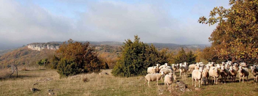
In the past, farms often consisted of several dozen sheep and a few goats that joined the herds from the plains that came up to the summer pastures every year. This was vertical transhumance, characteristic of the Mediterranean perimeter. Today the flocks are larger, but the systems have remained close to tradition. Today, transhumant pastoralism concerns about a hundred farmers and 125 herds, totaling about 23,500 animals. The income of pastoral farmers is frequently supplemented by agritourism or other agricultural activities, such as the cultivation of fruit or vegetables.
Classified Area
The site extends over a vast area of 3,000 km2 in the southern Massif Central. It includes part of the Parc National des Cévennes and the Parc des Grands Causses. It straddles two regions (Languedoc-Roussillon and Midi-Pyrénées) and four departments (Aveyron, Gard, Hérault, Lozère). Five cities provide access to the World Heritage site : Alès to the east, Ganges to the southeast, Lodève to the south, Millau to the west and Mende to the north.
Four distinguishable ensembles
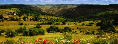
The Causses and the Cévennes present, in a stunning natural setting, a diversity of landscapes that belong to the same ensemble that has been shaped for centuries by man. And the base that connects them is the culture of agro-pastoralism. This culture is embodied today by its intangible heritage: the ancestral know-how and exceptional landscapes shaped by man. This culture combines the actions of nature and man for three millennia, representing the close relationship between agro-pastoral systems and their natural environment.

The Cévennes valleys are characterized by terraces, shale architecture, vegetation recalling the golden age of the chestnut and the structural heritage of sericulture (silkworm culture). The structure of the Cévennes valleys, in shale, without a foundation of cut rock, is particularly integrated into the environment.
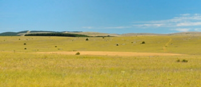
The mountains Aigoual and Lozère consist of grasslands, migratory herds and forests planted in the late 19th century. The fortress-like granite buildings are massive and made of heavy blocks.

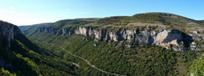
The Causses, karstic plateaus shaped by centuries of agro-pastoralism, are a good example of human adaptation to environmental conditions. The structure is built from limestone here, the only material available.
The valleys and gorges are terraced. As on the Causses, the architectural structures are made of limestone.
Cultural landscapes

Shaped landscapes
The area retains much evidence of the evolution of pastoral societies over many centuries. The importance of the structural heritage and landscape characteristics, as well as the transmission of ancestral knowledge, reflect traditional pastoralism and its conservation.
The Drailles
Historically, shepherds moved their herds between the plains and pastures through paths used for transhumance, called drailles. In the direction plain-mountain in summer, and in reverse in winter. Drailles represent a major element in the preservation of agro-pastoral traditions. They follow the crests of mountain ranges and exploit mountain passes, avoiding going down all the way into the valleys, which would slow the progress of herds. The Asclié, the Luzette, the Jalcreste and the Malons are the principal drailles.
Channels of communication in antiquity
The Voie Régordane
This road makes it possible to connect Languedoc to the Massif Central. Its existence is mentioned in texts from the 12th century. Remnants are visible in the Gard and Lozère departments in Concoules and Génolhac.
The Voie de Coudoulous
This access road links the Voie Régordane to the Languedoc draille (Mont Lozère). It goes from Portes to the Col de la Croix-de-Berthel in the municipality of Saint-Maurice-de-Ventalon.

The structures
Villages and farm buildings
The structures of the Cévennes valleys, in schist, are particularly integrated into the environment. Around the mountains Lozère and Aigoual, the massive granite structures have the appearance of fortresses. On the Causses and the gorges, the structural heritage was built in limestone, the only material available. Villages and large stone farmhouses located on the terraces of the Causses reflect the organization of large abbeys from the 11th century onward.

The clochers de tourmente
Widespread, especially in the villages around Mont Lozère, the “clochers de tourmente” (warning bells) served to guide travelers during storms (blizzard or fog) to prevent them from getting lost and dying of cold. In bad weather the bells would ring simultaneously, day and night, to guide them, like a lighthouse for ships. They were built around the 19th century.

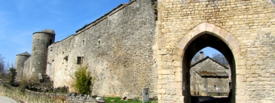
The castles from 1000 A.D.
Scattered throughout the territory, these fortified towers mark the beginning of feudalism. They represent the largest ensembles held by local lords, who sought independence with respect to the count guardianship. These buildings are in perfect mineral harmony with their environment, especially in the Tarn Gorges.

The Cévennes Romanesque church
During the first millennium, religious institutions became increasingly powerful. From the 11th century onward, many churches were built and would mark the Cévennes landscape, of which they are now an integral part.
The use of stone (shale, karst or sandstone, depending on the region) as a material for construction allowed for the seamless integration of churches into the landscape. Depending on the quality of the stone, sculpture is more or less present, abundant when sandstone is used (as it is easy to carve), and almost non-existent in the shale regions (the stone is too hard).
The Maison-Fortes
Fortified residences of lords, they appeared in the area at the end of the Middle Ages. Their fortifications (crenellated towers) are more aesthetic than defensive.

Smaller annex structures
The lavognes
A “lavogne” is a natural or man-made pond that collects runoff rainwater to water the herds. It is also frequented by wild animals. Conservation and maintenance of these water points are needed to preserve biodiversity on the Causses.
The sheep pens or jasses
The herds grazed over large areas, and when grazing lands or pastures were far from the farm, “jasses” (enclosed grazing fields) were built to spend the night.
The cultivation terraces
Geographical constraints had to be overcome at the cost of significant and ongoing works to build and maintain the terraces and their walls. These landscapes include aesthetic values, blending nature and culture. Wheat was grown on calcareous soils, and rye on granite or slate.
Other structures: the “clèdes” (chestnut dryers), the threshing floor (stone spaces set aside for threshing grain). These small structures contribute to the architectural and agropastoral landscape heritage.
Biosphere Reserve
The Cevennes National Park was designated a Biosphere Reserve by UNESCO in 1985. The basis of a biosphere reserve is the reconciliation of biodiversity conservation, economic and social development, and the maintenance of cultural values associated with it.
A living territory
A biosphere reserve is a living territory, chosen to be the field of application of the "Man and Biosphere" program of Unesco. It is a way of promoting economic and social development based on the preservation and development of local resources, and for which citizen participation is encouraged.
Transport
Five cities provide access to the site World Heritage site : Alès to the east, Ganges to the southeast, Lodève to the south, Millau to the west and Mende to the north.
Getting to the Causses and the Cévennes
By car
This is the recommended means of transportation for visiting the site, especially when traveling as a family.
Nearby classified
sites:
From the Pont du Gard to Florac via Alès :113 km (70 mi), time: 2 hours, 15 minutes.
From Arles to Florac via Alès : 141 km (88 mi), time: 2 hours, 30 minutes.
Canal du Midi (Béziers) to Vigan via Lodève: 115 km (71 mi), time: 2 hours.
By train
This means of transportation is not very convenient, as there is no train station within the site.
Intercity buses
Different bus networks operate routes to the site from the access cities.
Departmental Council of the Lozère
5 Rue de la Rovère
, 48 000 Mende
Website - tel : 04 66 49 66 66.
Departmental Council of the Aveyron
Place Charles de Gaulle,
12000 Rodez
Website - 05 65 75 80 00
Bus station in Millau
Rue Belfort
, 12100 Millau
Website - tel : 05 65 59 89 33
Departmental Council of the Hérault - Hérault Transport
Avenue du Professeur Viala, 34000 Montpellier
Website - tel : 04 34 88 89 99.
Departmental Council of the Gard - Edgard
Sreet Guillemette,
30000 Nîmes
Website - 08 10 33 42 73.
NTECC
15 Rue du Général de Gaulle, 30100 Alès
Website - tel : 04 66 52 31 31.
Getting around Causses and Cévennes
There’s nothing like actively discovering the riches of the classified site on trails for hiking, mountain biking or horseback riding.
Walking and hiking trails
For shorter family walks, the Causses and Cévanne parks have published many guidebooks. It is also possible to hike for several days on the national hiking routes (called Chemin de Grande Randonnées), and many paths run completely across the site.
By bike
Visitors can explore the site by bicycle, however this mode of transport should be reserved for experienced cyclists as the hills may be steep. Biking trail circuits exist on the Causse Méjean and Aigoual Massif. Inquire at the Tourist Offices.